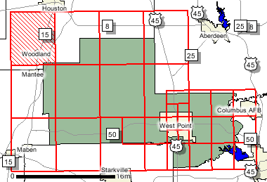
Map ModClay County
FEMA DFIRM Funding Year:FY2007
Status:
DFIRM EffectiveYou can access DFIRM data and maps at FEMA's Map Service Center (MSC)  County Index Map
 Flood Insurance StudyPreliminary DFIRM Panels
 (30)
 Note: Panel and map PDF files can be large, up to 75mb.
Meetings
Meet and Greet :
Scoping Meeting :
4/16/2008  Scoping Meeting Follow-Up
 :
Final Community Officials Meeting :
12/28/2009  "Flood Map Open House" Meeting
 :
12/28/2009 
Events and Documents
Proposed Studies Scoping Map  Preliminary DFIRM and FIS delivery
 :
11/17/200990 Day Community Appeal Start Date :
5/26/201090 Day Community Appeal End Date :
8/24/2010Letter of Final Determination Date :
11/3/2010Study Effective Date :
5/3/2011
County Seat: West Point
Formed: 1871 (Colfax County)
Area: 416 square miles
Population: 21,979
Origin of County name: Named for Henry Clay, the Kentucky statesman; name changed to Clay County in 1876.


