Project Status: Review Phase 469.7 square miles
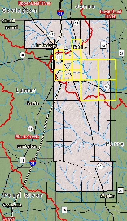
County Index Map
DFIRM Panels are provided as PDF documents.
Download a free PDF viewer.
Active Panels:
28035C0104E
28035C0107E
28035C0109F
28035C0114E
28035C0116E
28035C0117F
28035C0118E
28035C0119E
28035C0140E
28035C0145E
28035C0180E
28035C0185E
Meetings
Discovery Meeting - Lower Leaf River - 03170005
Nov 5, 2015 - Laurel, MS
Flood Risk Review - Lower Leaf River - 03170005
Mar 20, 2019 - Laurel, MS
Flood Risk Review - Lower Leaf River - 03170005
Mar 21, 2019 - Petal, MS
Preliminary DFIRM Community Coordination (PDCC)
Aug 19, 2019 - Laurel, MS
Flood Risk Open House
Aug 19, 2019 - Laurel, MS
Preliminary DFIRM Community Coordination (PDCC)
Aug 20, 2019 - Petal, MS
Flood Risk Open House
Aug 20, 2019 - Petal, MS
Events
Discovery Report Published - Lower Leaf River - 03170005
May 16, 2016
Preliminary DFIRM and FIS Delivery
Jun 28, 2019
90 Day Community Appeal Period
Nov 17, 2020
- Feb 15, 2021
Letter of Final Determination
To Be Determined
Study Effective Date
To Be Determined
Documents
Discovery Report - Lower Leaf River - 03170005
May 16, 2016Discovery Report (2.55 MB)
Flood Insurance Study (Preliminary)
Jun 28, 2019Flood Insurance Study Vol 1 (4.80 MB)
Press Release - Lower Leaf River - 03170005
Nov 13, 2020Forrest County Press Release ( MB)
County Seat: HattiesburgFormed: 1908Area: 470 square milesPopulation: 76,330Origin of County name: Named for Nathan Bedford Forrest, Confederate cavalry leader.